Cold Spring Brook: A Chronology of Abuses...
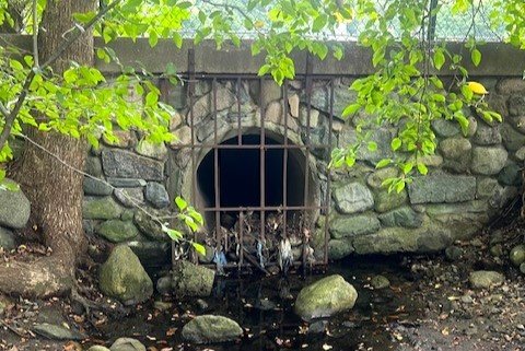
Cold Spring Brook where it first emerges from its long buried headwaters…
As part of a project to better understand the countless heavily compromised, overlooked, and underappreciated urban and suburban streams across the United States, NFC is taking a hands-on look at Cold Spring Brook in Newton, Massachusetts.
Cold Spring Brook is part of a sub-watershed that includes Hammond Brook and Laundry Brook, as well as Bulloughs Pond and two series of small ponds located in Newton Center Cemetery and on the grounds of Newton City Hall respectively.
The Cold Spring Brook watershed has been altered from its headwaters in Cold Spring Park all the way to where it empties into the Charles River. Streams have been moved, straightened, dredged, buried, and impounded. In fact, it is possible that nothing in the watershed is as it originally was…
Generations of abuse have left Cold Spring Brook looking more like a drainage ditch than a stream in most places…
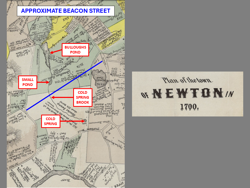
Cold Spring Brook originates at the long buried Cold Spring in what is now Cold Spring Park. It flowed through Cold Spring Swamp, originally known as Alcock’s Swamp. Further north it was joined by Hammond Brook, another beleaguered suburban waterway. From there down the stream was apparently known as Smelt Brook, and later renamed Laundry Brook, before terminating at the Charles River.
There were two ponds in the Cold Spring Brook watershed prior to 1700; Bullough’s Pond and a smaller pond to the south, referred to as Crystal Lake on some early maps. The latter is not to be confused with the notably larger and very popular lake of the same name to the east which was originally called Wiswall Pond and later Baptist Pond.
How the Cold Spring Brook watershed looked in 1700…
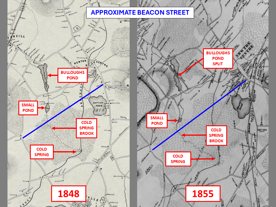
Bullough’s Pond was created in 1664 by a dam built on Smelt Brook to power a flour mill. Somewhere between 1848 and 1855, the pond was split roughly in half to facilitate the construction of Walnut Street. It was further altered somewhere between 1855 and 1929 by the construction of Commonwealth Avenue, the route of the fabled Boston Marathon.
Bulloughs Pond was apparently split sometime between 1848 and 1955 to facilitate the construction of Walnut Street.
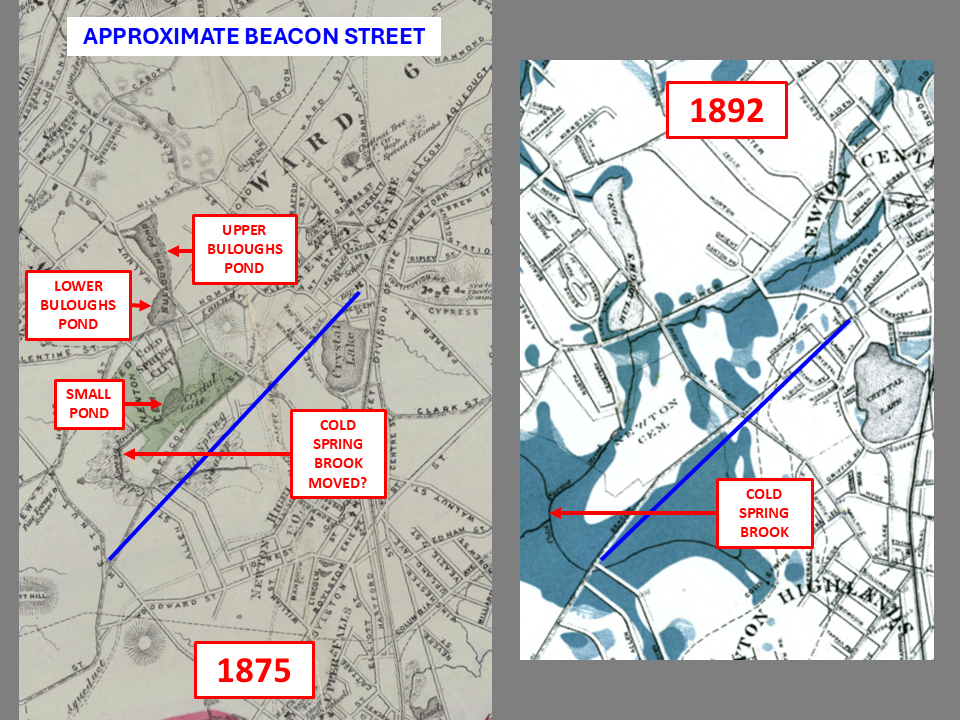
Based on a map dated 1875, it appears that upper Cold Spring Brook may have been moved to the west somewhere between then and 1855. An 1892 map shows the same thing. While the maps may not be accurate, we do know that the brook has been moved out of its original channel. Whether this was done twice or once is not clear. Note that a 1929 map shows the stream in a different place.
If accurate, the 1975 map shows Cold Spring Brook well to the west of where it appears on early maps.
The southern section of Bullough’s Pond is now 3 smaller ponds connected by short sections of stream on Newton City Hall property. Upstream and downstream of these ponds, Cold Spring Brook is culverted and buried beneath yards and roads. A 1929 map shows this section as a single canal-like stream, so it is possible that it was altered more than once.
The aforementioned smaller pond south of the original Bullough’s Pond is now 4 small ponds located within Newton Center Cemetery. While the 2 westernmost ponds are connected by a section of open air stream, the 2nd, 3rd, and 4th are connected by buried culverts. Cold Spring Brook upstream and downstream of these ponds is buried as well.
Both the lower section of Bulloughs Pond and the small pond to the south have been split into multiple ponds.
(the maps above are courtesy of the City of Newton)
Today, upper Cold Spring Brook flows more or less straight north from its buried headwaters in Cold Spring Park, before making three 90-degree turns prior to disappearing under an elementary school. It is doubtful that this is its original course due to what is a trapezoidal shaped stream channel as well as the straightness and 90-degree bends.
Note the absolute straightness and 90-degree bends in the upper section of Cold Spring Brook…
It would be difficult to trace Cold Spring Brook, Hammond Brook, Laundry Brook, or the several small unnamed tributaries with absolute accuracy. The subterranean sections of these streams were straightened, moved, culverted, and buried long before anyone alive today was born. And while maps exist, their accuracy is not guaranteed.
What we do know, and as you can see above, like many suburban and urban waterways, the Cold Spring Brook watershed has been notably altered. The alterations began over 350 years ago, and continue to this day in the form of dredging to control stormwater run-off.
The good news is that there is a movement taking hold across the nation to “daylight,” or unbury, and restore heavy altered suburban and urban waterways. Whether the Cold Spring Brook watershed will be one of them is yet to be determined…
A section of upper Cold Spring that is starting to resemble a natural stream…


