New Hampshire's Zealand River: Just When You Thought it Couldn't Get Any Worse, it Did, and Much Worse...
While not perfect, the Zealand River was one of the better larger wild native brook trout streams in the White Mountains region of New Hampshire. The section of stream above has been permanently dewatered by USFS as part of a project to save a road that never should have been built.
Few if any rivers have suffered as much at the hands of man as the Zealand River in New Hampshire. Starting before many reading this were born, the Zealand River has been subject to extensive gabion construction, bulldozing, straightening, rip-rap bank construction, unchecked angler exploitation, and decades of state-sponsored stocking.
While the Zealand River was written off by some as a pure put-and-take fishery unfit for wild native brook trout, that was not the case. While fish abundance varied from one year to the next, some years, and as recently as less than a decade ago, the Zealand River teamed with wild native brook trout. You just had to go further away from the road than the average angler and away from the stocking sites...
A bulldozed, straightened, and rip-rapped section of the Zealand River next to the road…
Between 1960 and 1963 in what is said to be the second oldest major stream-stabilization project in the United States, hundreds of feet of gabion wall and dozens of gabion weirs and grade-control sills were constructed on the Zealand River to try to control and contain the flow. This was done in response to severe flooding that occurred in the late 1950’s.
Over time the gabion walls were undercut, collapsed, and torn away from the bank by high water events. Mid-river weirs and sills were flattened, broken apart, and pushed downstream. The river pushed toward the outside banks as rivers do, leaving expansive gravel bars and gabion structures high and dry as much as tens of feet away from the water.
The Zealand River channel was dug down as a result of being constrained by gabion walls. This detached the river from its historic floodplain and expedited further channel cutting. It also speeded up the flow sending water rushing downstream every time it rained and during spring run-off. Then the epic floods of the 2000’s did more damage to the river in a few years than had been done in the decades prior to that.
Failed gabion structures littered the Zealand River for decades, getting worse as floods worsened…
As floods worsened and previous attempts to control the Zealand River failed, sections of a dead-end road that parallels the river were washed out. The road provides access and parking for hikers, including those staying at a backcountry AMC hut, while allowing the town of Bethlehem, New Hampshire, to maintain a dam that blocks fish passage and siphons more than 575,000 gallons of water a day for municipal use.
Once again the Zealand River began to chew away at the road as it had done in the late 1950’s which triggered the initial attempt to control the river. And as it had done then, the threat to the road mobilized the powers that be to act to save a road that never should have been built in the first place. And once again the heavy hand of man was turned loose on the river, only this time to fix damage caused by the heavy hand of man…
A small fish-blocking dam on the Zealand River used to siphon water out of the river for municipal use.
Problems with regard to maintaining the road and increasing damage to the river led USFS to undertake an effort to, as NFC was told, reconnect the Zealand River with its historic floodplain. As the riverbed deepened as a result of being trapped by gabion walls, historic floodplain channels were left high and dry even in the wettest years. This increased the scouring, deepening, and widening of the riverbed.
While touring the area with USFS Zealand River project leader Mark Prout several years ago, we inspected long dry flood channels lined with river cobble but buried in years’ worth of leaves. Reconnecting the river to these channels to lessen damage to the mainstem during flood events made sense. And dismantling the gabion and putting the rocks back in the riverbed where they came from seemed to be the best way to do it.
A collapsed section of gabion wall that prevents the river from jumping its bank during high water events.
Before the construction phase of project had begun, Mother Nature intervened and opened up a long dry flood channel just downstream of one of the longer sections of gabion wall. Subsequent rain events pushed a portion of the water down the channel and away from the mainstem river and road, exactly what we thought USFS wanted to do.
Two years later, members of NFC stumbled on a construction site that looked as though USFS had started the project. A section of gabion wall had been deliberately pulled away from the bank and deposited in a way that blocked fish passage. That this was just upstream of an important spawning tributary made it all the more concerning.
When we returned to the site a couple of weeks later, things had gotten notably worse. USFS was not dismantling the gabion, they were as Prout said when asked, “…moving the river.” While not rerouted at the time, there were clear signs that some yet to be determined length of historic riverbed was going to be dewatered to protect the road.
While USFS used historic channels to reroute the Zealand River, it appears that they have taken some geological liberties. The maps below show that the bulk of the river water travelled in the westernmost channel as far back as the early late 1950’s, and likely much longer than that based on the extent of the streambed erosion visible in the images.
While the middle channel carried some level of water in the early 1960’s, by the 1990’s it appears to have been long dry. The fact that the middle channel exited the mainstem at a roughly 60 degree angle indicates that it was a secondary channel not the primary channel. Conversely, the easternmost channel was dry by early 1960’s and possibly much earlier than that. Based on its size, it is unlikely that the easternmost channel ever carried the bulk of the river flow.
As you can see from the maps, moving the river into the middle channel would be easier to defend than moving it into the easternmost channel. However, the middle channel rejoins the westernmost channel upstream of one of the two problem areas in regard to maintaining the road. Conversely, the easternmost channel rejoins the mainstem downstream of both problem areas on the road.
While the middle channel branched off from the westernmost channel at a roughly 60 degree angle, the new opening dug to facilitate rerouting the river into the middle and easternmost channels was cut at a roughly 130 degree angle. This was likely done to lessen the impact of high water events on the newly constructed dam on the westernmost channel. Based on historic maps this was never the case.
Based on where the new river channel rejoins what has been the mainstem Zealand River for generations, it appears that USFS started by rerouting the river into the middle channel just upstream of Hale Brook and then cut eastward into the easternmost channel. Based on maps we have looked at, there has not been a natural connection between the two channels in generations, and the easternmost channel exited the mainstem upstream of the construction site.


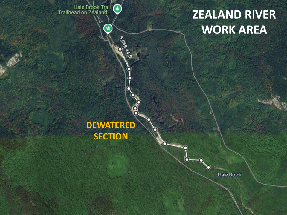
The mainstem of the Zealand River will now flow well east of where it has existed for generations, and possibly centuries. Based on the picture below, the new river channel is more than 600 feet east of what most people alive today known as the historic river channel. And there are no plans that we are aware of to fix the now dewatered channel.
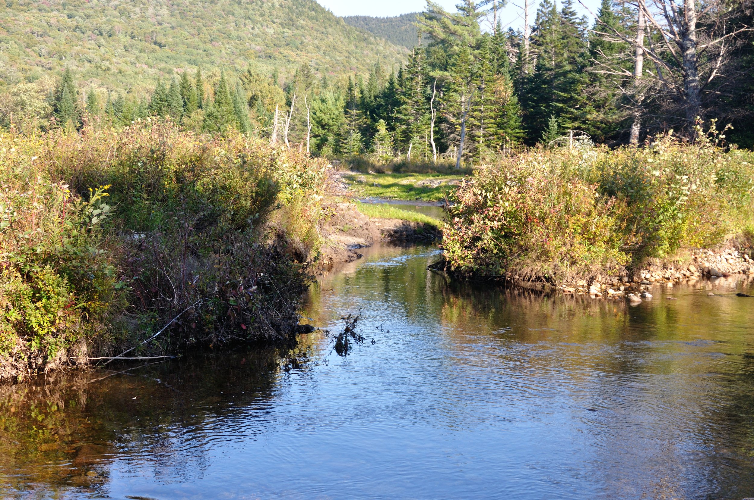
How this new river channel will stand up to the elements is yet to be determined. But the Zealand River is prone to flooding during high water events, and the new channel is notably narrower and shallower than the old one. It also looks to be straighter and sans structure which could speed up the flow.
Top/Right: Freshly dug channel now carrying the bulk of the Zealand River flow…
The impact that rerouting the Zealand River will have on the wild native brook trout that have persisted in the river for thousands of years is yet to be fully understood. Prior to rerouting the river, USFS relocated hundreds of wild brook trout upstream of the new dam. This was done in the fall and at a time when brook trout would start moving into historic spawning habitat, including just downstream of the dam.
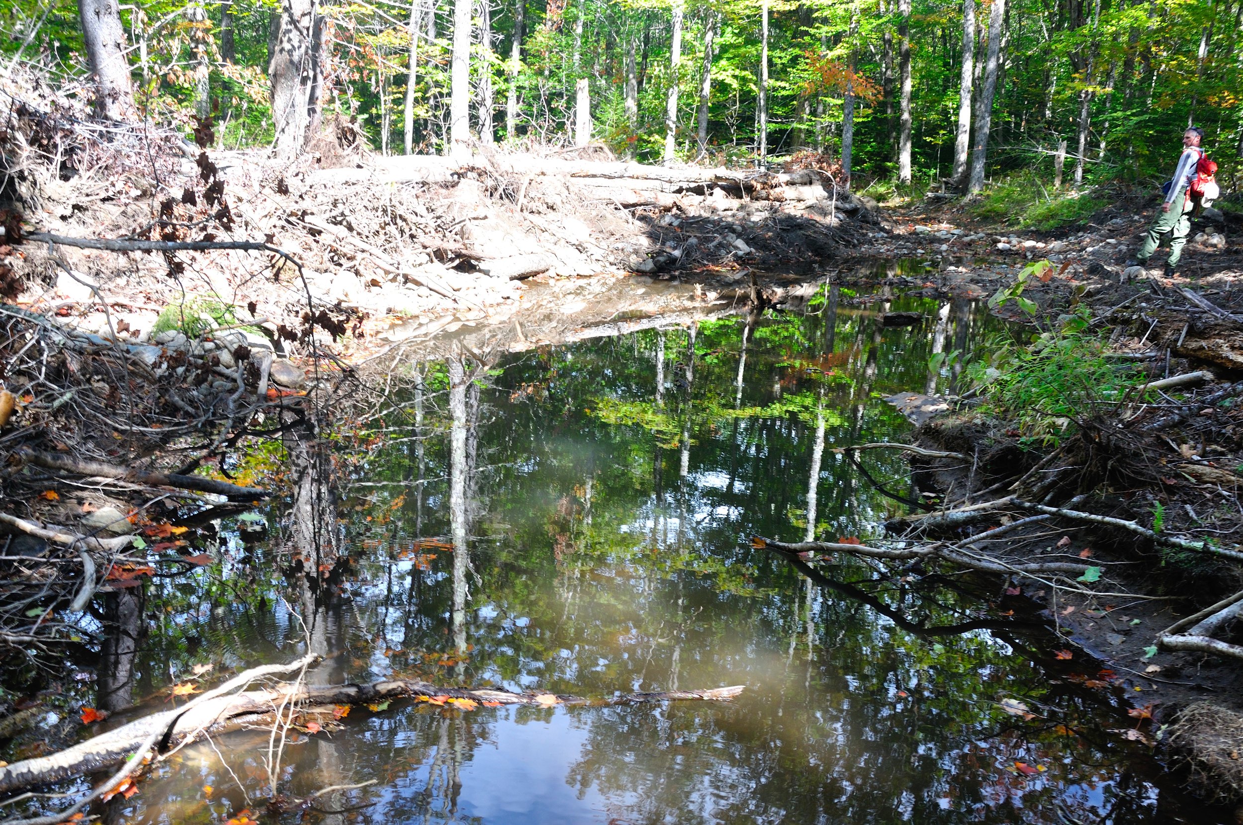
Historically, an important brook trout spawning tributary emptied into the Zealand River 100 feet or so downstream of the new diversion dam and within the now dewatered section of river. Manipulated like the river itself, the stream now travels 150 feet or so through open and bulldozed riverbed before disappearing into the recently opened flood channel mentioned above at a smaller manmade diversion dam. It is then rerouted into the new river channel.
The alteration to the Zealand River and spawning stream lengthens the distance brook trout will have to travel to reach the spawning habitat from the river notably. Will the fish be able to find it? Will they be able to navigate the new channel to reach suitable spawning habitat? Will juvenile fish be able to get back to the river? If they can’t, what impact will this have on recruitment?
An important brook trout spawning tributary now emptys into a dewatered section of river.
Before the diversion dam cut off the river water…
The spawning tributary is now the only water flowing through 100 feet or so of dewatered riverbed.
The new channel on the Zealand River rejoins the historic channel at what was known as the Wildlife Viewing area. There was a series of small shallow ponds backed up by gabion wall that were fed by small streams to the east of the river. As noted earlier, at one time it appears it was also fed by a seasonal flood channel that exited the river upstream of the new diversion.
Recent satellite images show what look like new ponds upstream of the wildlife viewing pond. Whether that are temporary or put there to buffer the river flow is unclear, and getting answers out of USFS has proven to be difficult at best. But based on a day spent trying to figure out what water was going where; it looks as though this is where the main flow will return to the historic Zealand River channel.
The breached gabion wall that once held back the wildlife viewing pond.
Just upstream of the where the new river channel reenters the historic riverbed.
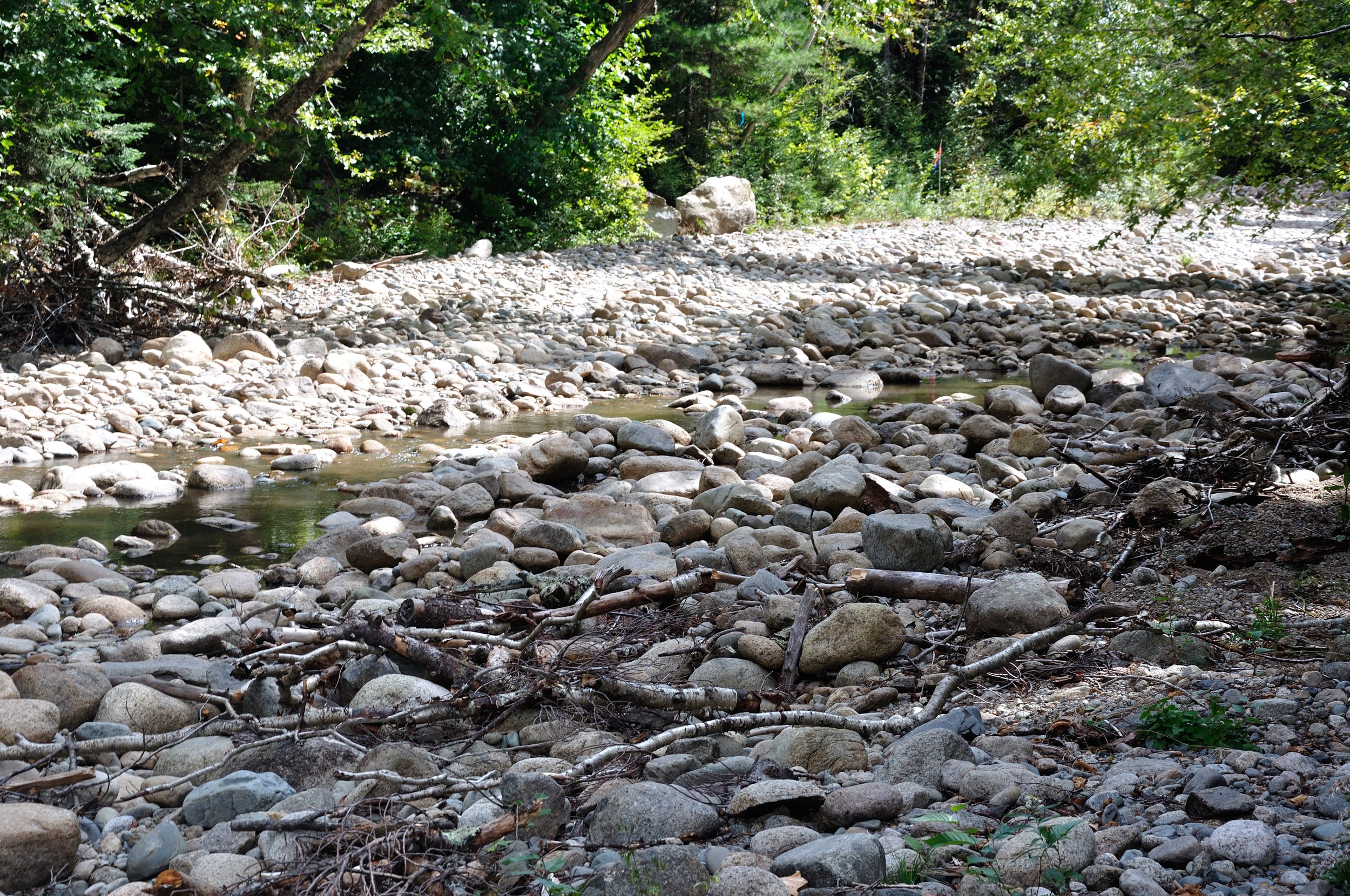
By the time the new river channel rejoins the historic river channel, nearly a mile of generations old Zealand River streambed has been left dry with the exception of groundwater seeps, small tributaries, rain and snow run-off, and puddles. The ill-advised gabion still stands for the most part, but it is no longer part of the active river channel and therefore not a problem to the powers that be.
The newly dewatered section of the Zealand River will stand for generations as a testimony to what man can do to a natural resource when we are allowed to. Aesthetically, the Zealand River will never be the same. While folks will notice the mile of dewatered streambed, most will not know why it is that way.
A dewatered section of the Zealand River.
We damaged the Zealand River in the early 1960’s to try to save a road that never should have been built. We dammed the river and pull 500,000 gallons of water a day from it for a municipality. We refused to protect the wild native brook trout from angler exploitation, then tried to mask the problem with annual stocking. Now we have moved the river to protect the road rather than address the gabion that was causing the problem.
While there are those who believe that the river was too far gone due to scouring caused by the gabion and flood damage, I don’t agree. As someone who has fished the river hundreds of times over the last half a century, I can say firsthand that the wild native brook trout were still there. An indicator species, the presence of wild brook trout should have told us that fixing what was there was a better strategy than moving the river.
A section of Zealand River that carried the main flow for generations has been bulldozed and filled to force the river hundreds of feet away from the road.
What the future holds for the Zealand River is unknown. We now need to let it play out, and we will not know the complete impact for years. Will the river stay where USFS tried to put it? Will the new habitat hold up to what Mother Nature throws at it? Will the river be conducive to wild native brook trout in the abundance levels that existed prior to it being rerouted?
I will revisit the Zealand River next year as I have for nearly 50 years. I’ll walk the new river channel to assess its impact on the wild native brook trout. I’ll push up the spawning tributary to see whether wild native brook trout can do the same. I’ll even fish the river. But to be clear, USFS just stole from me, and everyone else, a high potential stretch of wild native brook trout river that can never be replaced.
The way I want to remember the Zealand River…
We wish we had plugged into what was going on at the Zealand River much sooner than we did. While NFC was invited to see a presentation in regard to the planned river alterations, we were not in a position to do so due to turnover in our NH chapter. According to USFS, they presented their plan to at least one local fish conservation organization. Why were they not concerned with a huge project that would literally move a river?
The Zealand River was admittedly in trouble due to faltering gabion, increased channel cutting, and increasing damage from flooding. While something needed to be done, we do not believe that moving the river was the best and least negatively impactful way to address the problem. In fact, it may have been the most negatively impactful way. The last time we tried to “fix” the Zealand River we only made it worse. We can only hope the outcome is better this time…
Reader Note: The pictures above were taken while construction was being done. The flow had not fully moved into what appears to be the new channels. And water was still present from the initial drawdown of the historic channel. We suspect it will look notably different next year when everything has stabilized.


