Cheesecake Brook: Water Temperature Snapshot...
As part of a multi-faceted stream assessment/restoration project on Cheesecake Brook in Newton, Massachusetts, NFC recently partnered with Charles River Watershed Association to deploy temperature loggers in various locations on the stream.
A heavily manipulated and often buried urban stream, the group looks to ascertain the impact of subterranean flow, long above ground treeless secitions of stream, and underground inputs, some of which are not mapped.

Please note that the logger at Crafts Street stopped recording around 5/23 for some reason. We are working to fix or replace it. We were also unable to locate the logger placed in the mainstem Charles River. It likely got dislodged by high water.
A quick look at the initial 2 weeks’ worth of data downloaded when we checked the loggers to see if they were recording properly showed some interesting trends:
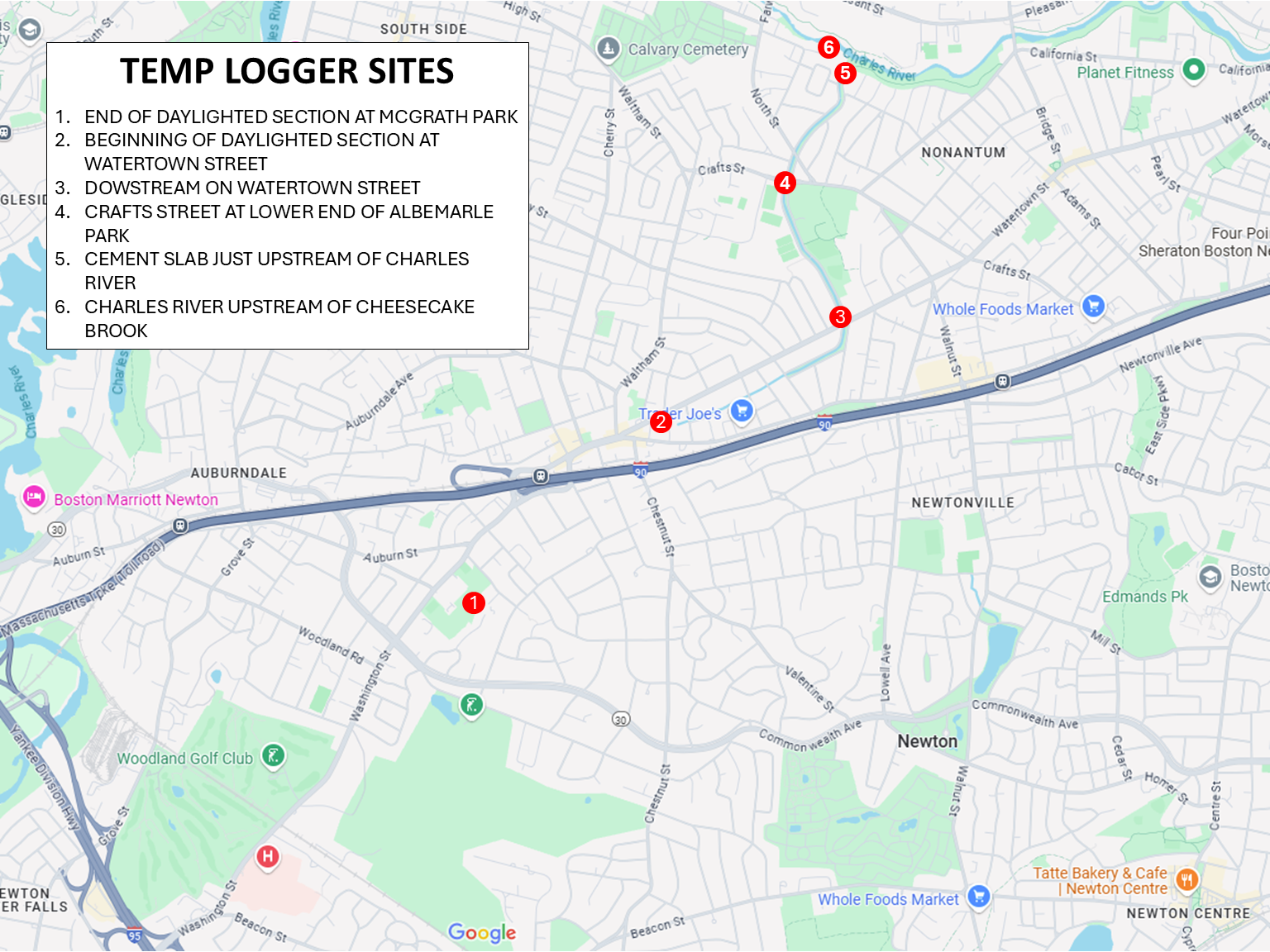
McGrath Park is the end of a mostly above ground, or daylighted, section of stream in the headwaters of Cheesecake Brook. The stream flows through a golf course mostly devoid of canopy, then into a small shallow impounded area, before going underground for 500 or so feet, then resurfacing just upstream of the park. The excessive temperatures and spikes are likely due to a lack of canopy. Unfortunately, we have been unable to gain access to the property where the stream first surfaces to establish a baseline.
Cheesecake Brook daylights again roughly a mile downstream of McGrath Park near the intersection of busy Watertown Street and Washington Street. The roughly 20-degree cooler water encountered here is likely the result of the stream being subsurface and unaffected by the sun and warm air. How much of the initial warming is the result of a lack of canopy in the gold course and the small, impounded area is unclear.
Crafts Street is roughly a mile downstream of the Watertown Street logger. While the upper half runs through an area with good tree cover, the lower half runs through a manicured green belt with very few trees. Prior to it shutting down, the temperature was relatively consistent with the upstream logger, but with more notable spikes, likely due to a lack of canopy.
The logger on Cheesecake Brook just upstream of the Confluence of Charles River shows the most radical temperature spiking of all sites on the stream. It experiences some of the coolest water in the stream, likely at night and early morning, yet sees some of the highest temperatures, likely due to midday periods of warm air temperature and high sun.
The data collected from temperature logging phase of the project will be used to assess what the stream is capable of supporting, as well as what could be done to improve water temperature in regard to highs and spikes.

Cheesecake Brook at Albermarle Park…